An interesting story on polluted places was posted on National Geographic with photos, Ten Most Polluted Places Named. Check it out here.
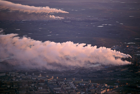
Noril’sk, Russia (image from national geographic article)
The list was put together by the Blacksmith Institute, a New York City based organization supporting pollution-related projects. To be honest I was pretty much unaware of most of those places on the list, but most of us already know Chernobyl is going to be on there even before we check it, which got me thinking about some other places and happenings not as well known to most people. Lake Karachay in Russia for example, or Vozrozhdeniya island in the Aral Sea.
Lake Karachay (Russian: Карача́й) is a small lake in eastern Russia, and was used as a dumping site for radioactive waste by the Soviet Union. The radioactive waste came from a nearby nuclear waste storage and reprocessing facility known as Mayak Chemical Combine, located near the town of Chelyabinsk-40 (now known as Ozyorsk).
Between 1948 (Mayak’s first year) and 1951, the Soviets would dump liquid waste into the river Techa which extends right into the Arctic ocean. When they found out about the radiation in the Arctic waters of northern Russia, they stopped and began dumping the radioactive waste in Lake Karachay instead. In 1953 when their permanent storage facilities was built and ready they stopped dumping high level waste, but continued dumping medium and low level waste into the lake.
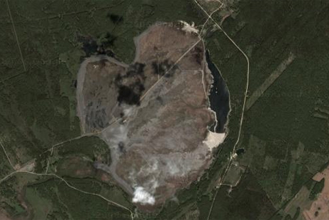
Lake Karachay, Russia. Filled with concrete. (google map image)
Click to go to Lake Karachay on google maps
In 1957 a cooling system for one of the tanks holding waste in the storage facility failed, and it resulted in an explosion (force of 75 tons of TNT) and radiation was released into the atmosphere. Most of it came back down onto the complex, but a radioactive cloud 5 miles wide formed and traveled over the Chelyabinsk province. The radiation came down on an area approximately 23,000 km2 with over 270,000 inhabitants. The hospitals in the region were filled to capacity the next two years, and it’s hard to say how many died resulting to the explosion due to inadequate medical records.
Back to the lake itself. In 1967 the third major nuclear incident would take place. The lake began to dry out and strong winds in the region carried radioactive dust and spread it out over an area roughly the size of Maryland or Belgium. It is believed that over 400,000 people were affected by this incident. The lake supposedly holds over a 100 more times the amount of strontium 90 and cesium137 than was released at Chernobyl. According to the Natural Resources Defense Council the lake holds about 120 million Ci of radiation.
Between 1978 and 1986 the lake was filled with almost 10,000 hollow concrete blocks to prevent the sediments from shifting, and the lake is today covered in concrete. Unfortunately the radiation has begun spreading into the local underground water tables, and the entire regions waterways lead to the Ob river which extends into the Arctic Sea.
Vozrozhdeniya island (English: Renaissance Island, Russian: Остров Возрождения) used to be an island in the middle of the Aral Sea, and is now a peninsula due to the shrinking of the sea. In 1948 a top-secret bioweapons laboratory was established on the island, and the island was used as an open-air testing site for different types of biological weapons.
It was most likely chosen because of its geographical location, in the middle of the aral sea surrounded by huge sparsely populated deserts. The island was abandoned by the laboratory staff in 1991, and many of the containers storing the anthrax spores and other were not always properly stored or destroyed, and some containers developed leaks.
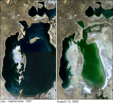
The aral sea (image from http://earthobservatory.nasa.gov/)
In 2002 an expedition was led by Brian Hayes from Pentagon’s Defense Threat Reduction Agency to neutralize what was likely the world’s largest anthrax dumping grounds. His team of 113 people neutralized between 100 and 200 tons of anthrax over a three-month period.
Scientists fear animals will eventually carry deadly biological agents with them from the area now that it has become a peninsula.
info from wikipedia articles, and some of the external links